Geospatial Technology (Aerial Surveying and Remote Sensing Application Domain) have high potential for better management and monitoring of day-to-day activities and short-term and long-term physical processes that affect our living environment. Several aspects of space technology have already touched the life of common people, e.g., Google Earth, GPS-enabled Mobiles and day-to-day navigation, using maps. All the technologies behind these services, when put in one basket. This includes satellite remote sensing, airborne remote sensing, photogrammetry, geographical information system (GIS), Global Positioning System (GPS), electronic surveying, laser scanning, mobile mapping, image processing, algorithms, data structures and computer programming.
Domain Track: Aerial Surveying and Remote Sensing Applications
Course Attendees
Still no participant
Course Reviews
Still no reviews
Track Total Credits ( T-P-P): 4-10-4
Courses Division:
- Remote Sensing & Digital Image Processing (CODE: CUAS2020) (2-2-0) 45Hours
- Geospatial Technology and its Application (CODE: CUAS2021) (2-2-0)45Hours
- Photogrammetry and its Application (CODE: CUAS2022) (0-2-0) 25Hours
- Lidar Remote sensing and its Applications (CODE: CUAS2023) (0-2-0) 25Hours
- Hyper-spectral Remote Sensing and its Application (CODE: CUAS2024) (0-2-0) 25Hours
- Project (CODE: CUAS2025) (0-0-4) 54Hours
Domain Track Objectives:
The Aerial Surveying and Remote Sensing Application is a skill-based industry integrated domain course. It is delivered in a unique experiential learning process of interactive hands-on sessions, beginning with essential theoretical foundations, and progressing to learning how to effectively apply them in the real world. To facilitate effective learning, this technology is becoming essential for a large number of application domains, e.g., environmental sciences, civil engineering, urban development and management, water resource, geology, navigation, disaster management, forest, coastal zones, mining operations, entertainment, and many more. Geomatics encompasses the practices related to developing, managing, interpreting or analyzing geographically referenced data and includes everything that is ‘spatial’ in its characteristic and content. Geospatial information empowers the nation to understand its topography, natural resources and human capital and allows it to develop the requisite industrial policies to harness its resources. The objective of this domain is
- Use geospatial tools and techniques for natural resources planning and management.
- Pursue research and develop capabilities to handle multi-disciplinary field projects.
- Work in teams and demonstrate leadership skills with professional ethics
- Apply the principles of Remote Sensing and GIS to collect, map and retrieve spatial information.
- Plan, assess and evaluate natural and manmade systems using geospatial models and methods.
- Use geospatial tools and techniques for natural resources planning and management.
- Pursue research and develop capabilities to handle multi-disciplinary field projects.
- Work in teams and demonstrate leadership skills with professional ethics
Domain Track Learning Outcomes:
- Identify specific data and methodologies for effective mapping and evaluation of natural resources.
- Develop geospatial models and tools to address the social and engineering problems
- Design multi-criteria geospatial systems for decision-making process
- Work in a team using geospatial tools and environment to achieve project objectives.
- Pursue lifelong learning for professional advancement
Career Scope:
- Indian Space Research Organization (ISRO) - [Space Application Centre (SAC), Indian Institute of Remote Sensing (IIRS), ISRO State application Centre, Orissa Space Application Centre (ORSAC)].
- Survey of India (SOI)
- Indian Rice Research Institute (IRRI)
- Defence Research & Development Organization (DRDO)
- Urban Authorities of India
- Forest department [Odisha Forest Sector Development Project (OFSDP)]
- Chilika Development Authority (CDA)
- Odisha PVTG Empowerment Livelihood Improvement Programme
- Odisha Tribal Empowerment & Livelihoods Programme Plus
- Odisha State Disaster Management Authority (OSDMA)
- Bhubaneswar Municipality Corporation (BMC)
- Indian Institute of Mineral and Material Technology (IMMT)
- AABSys
- Institute for Spatial Planning and Community E-services (I SPACE)
Domain Syllabus:
1. Remote Sensing and Digital Image Processing (Code: CUAS2020) (2-2-0) 45 Hours
1.1 Basic Concept of Remote Sensing (4+6) Hours
Introduction of Remote Sensing: Principles of RS and its Type; Energy sources and Radiation principles, Pixel, DN value, Energy equation; EMR and Spectrum; EMR interaction with Atmosphere; scattering, Absorption, Atmospheric window, Black body radiation; EMR interaction with earth surface features, reflection, absorption, emission and transmission, Spectral signature; Interaction with vegetation, soil, water bodies; Advantage of RS over conventional method, Limitation, Ideal remote sensing.
Practice:
- Installation of Image Processing software’s
- Download satellite data from GLOVIS / Earth Explorer / Bhuvan etc.
- Layer stacking
- LUT and Image Subset
- Spectral Signature mapping (soil,vegetation,water)
1.2 Digital Image (2+3) Hours
Data acquisition: Procedure, Reflectance and Digital numbers; Intensity, Reference data, Ground truth, Analog to digital conversion, FCCs, TCC, Platforms and sensors; orbits ,types, Resolutions; Image Interpretation; visual- Interpretation keys.
Practice:
- FCCs and TCC
- Resolution
- Image Interpretation
1.3 Satellite Information and Principles (2+3) Hours
Land observation satellites, characters and applications; PSLV, GSLV, Satellite, Platform Types; LANDSAT series; IRS series; IKONOS Series; QUICKBIRD series; Weather/Meteorological satellites; INSAT series, NOAA, Applications, Marine observation satellites; OCEANSAT
Practice:
- Image filtering and Band ratioing
- Mosaicking
1.4 Image Acquisition and Format (2+4) Hours
Digital Image Processing; Export and import, Data formats; BSQ, BIL, BIP, Run length encoding, Image Compression Data products.
Practice:
- Export and Import
- Histogram
- Subset using AOI
1.5 Image Processing (3+4) Hours
IMAGE RECTIFICATION; Preprocessing and Post processing Geometric distortion; sources and causes for distortion, rectification, GCP, Resampling, Image registration; Radiometric distortion; sources and causes, atmospheric correction
Practice: (Spectral Python and ENVI)
- Geometric correction
- Radiometric correction
- Atmospheric correction
1.6 Image Classification (4+4) Hours
IMAGE CLASSIFICATION; Classification techniques, types, Supervised and Un-supervised; Principal Component Analysis (PCA); Image Enhancement; Accuracy assessment.
Practice:
- PCA analysis (spectral Python and ENVI)
- NDVI, DVI, NDWI calculation
- Image classification in Spectral angel Mapper
- MNF Ratoing
- Supervised Classification(spectral Python and ENVI)
- Un-supervised Classification(spectral Python and ENVI)
- Image Enhancement( ENVI)
- Accuracy Assessment(ENVI)
1.7 Remote Sensing and Its application (3+4) Hours
Microwave RS and its application; Thermal RS and its application; Optical RS and its application; Sensor and its types.
Practice:Using Spectral Python
- Application of microwave remote sensing (Structural Trend line mapping)
- Application of thermal remote sensing and case study(Land surface Temp.estimation)
- Application of optical remote sensing and case study
2. Geospatial Technology and its Application (Code: CUAS2021)(2-2-0) 45 Hours
2.1 GIS &Cartography (2+4) Hours
Components of GIS, Types of Data in GIS, Scale Application of GIS, Advantage and limitation of GIS. History and development of Cartography; Definition, scope and concepts of cartography, Characteristics of Map; Categories of maps, Methods of mapping, relief maps, thematic maps.
Practice:
1.Symbology (generalization, symbology, and coloureffect, change symbology and use transparency in creative ways) using GRASS and QGIS
Geo-referencing (Map to Image and Image to Image), Projection, Data base creation: Digitization using Point, line and polygon, Edit, Clip, Intersect, Union, Merge, Join and subset. Attribute table editing
2.Google Earth (Convert Shape file to KML Format and KML File to shape file, Import data into Google earth, Bhuvan view, Extract data From Google Earth, Extract Point Data, Extract Polygon data, Extract line data, overlaying an image into Google earth)
2.2 Data analysis tools(2+4) Hours
Raster data spatial analysis, Network analysis, Vector operations and analysis, Data editing, Primary and secondary data. Data model and data structure, Geodatabase and metadata, GIS data model, Overlay analysis, Network modeling, Data Structure Models, Spatial interpolation; measurement and analysis methods, Advantage and disadvantage
Practice:
- Linking of spatial and Non-spatial data and queries, Joining tabular data with the feature attribute data, Non-spatial query, Spatial query, Spatial join, Vector based spatial analysis, Raster based spatial data analysis
- Buffering and Creation of Contour
- Network Analysis
2.3 Multi-criteria analysis and decision making (3+4) Hours
Principles and elements of multiple-criteria decision making, Classification of Multiple-criteria Decision Problem: Multi-objective Vs Multi-attribute, Decision Alternatives and constraints, Criterion weighting, Decision rules, Multiple-criteria decision making in spatial data analysis.
Introduction to AHP, Basic Principles of AHP, Effect Table, Pair Wise comparison, Consistency, Weightage, performance score, Case studies involving AHP
Practice:
- Mapping accident locations using Linear Referencing technique.
- Preparation of raster layers for Multicriteria Analysis
- Solving a spatial problem using Multicriteria Analysis (Spatial AHP)
2.4 Digital Elevation Model (DEM) (2+4) Hours
Concept of DEM, Various techniques to generate DEM, Importance of spatial resolution to DEM, Integration of DEM to satellite data, Common derivatives of DEM, Slope, Aspects, TIN, Sources of DEM, Laminations and future of DEM.
Practice:
- Google earth to DEM, 3D Map preparation, Contour to DEM, TIN and Aspect
- DEM based surface Hydrology modeling,
- LiDAR classification, DEM from LiDAR
2.5 Geospatial Technology for Water resources Engineering (3+4) Hours
Watershed, types, divide catchment, command area, stream types, Drainage network, different pattern; morphometric analysis, Bifurcation ratio analysis; Assessment of Groundwater potential zones and Groundwater mapping; Site selection for recharge structures, Hydrogeological Mapping GIS applications to ground water studies.
Practice:
- Mapping of catchment, command area
- Drainage network analysis
- Morphometric analysis
- Mapping of Groundwater potential zones
2.6 Geospatial Technology for Environmental Engineering (3+4) Hours
Monitoring atmosphere constituents; air pollution, industrial activity, modeling using GIS, Resource development in remote areas, Impacts of anthropogenic activity, Solid Waste management; Water Pollution, Shortest path Identification, Network analysis.
Practice:
- Air pollution mapping
- Solid waste management
- Water pollution
2.7 Web GIS (3+4) Hours
FOSS and its use in web mapping; Designing web services and web maps, storing and processing spatial data with FOSS, Drawing and querying maps on the server with WMS, Putting layers together with a web mapping API, Drawing vector layers with the browser.
Practice:
- Designing web services and web maps
- Drawing and querying maps on the server with WMS
- Putting layers together with a web mapping API
3. Photogrammetry and Application (Code:CUAS2022) (0-2-0) 25 Hours
- 3.1 Scale determination from aerial photo
- 3.2 Aerial photo Interpretation
- 3.3 Use of Parallax bar and determination of Height from stereo pair
- 3.4 Satellite DEM and ortho Image generation
- 3.5 Primary and additive colour creation
- 3.6 Stereo test
- 3.7 Mosaic
- 3.8 Stereoscopic vision
- 3.9 Relief displacement
- 3.10 Analog to digital conversion,Orientation of stereo model and Determination of Height
- 3.11 Aerial mapping using DRONE
- .12 Mosaicking of aerial Photo
- 3.13 Correction and rectification
- 3.14 DTM generation ,Image correction ,Link between GIS and Digital Photogrammetry and Ortho Image generation
4. LIDAR Remote Sensing and Application (CODE:CUAS2023) (0-2-0) 25 Hours
- 4.1 Download of LIDAR data
- 4.2 Layer stacking
- 4.3 Data Validation
- 4.4 Georeferencing Technology
- 4.5 Boresight Calibration - Lidar Data Preprocessing
- 4.6 Project Coverage Verification - Review Lidar Data against Field Control
- 4.7 Lidar data errors and rectifications, - processes calibration of Lidar data - artifacts and anomalies - Lidar Error Budget.
- 4.8 Noise Removal and other sensor-related artifacts - Layer Extraction - Automated Filtering
- 4.9 Manual Editing and Product Generation – Surface Editing - Hydrologic Enforcement
- 4.10 Breaklines, Contours, and Accuracy Assessment
- 4.11 Topographic Mapping, flood inundation analysis, line-of-sight analysis
- 4.12 Forestry, various types of LIDAR sensors-, vegetation metric calculations - specific application software.
- 4.13 Corridor mapping system, data processing and quality control procedures.
- 4.14 Modelling
5. Hyperspectral Remote Sensing and Application (CODE: CUAS2024) (0-2-0) 25 Hours
- 5.1 Introduction to ENVI, Python and Downloading, Displaying, and Analyzing Hyperspectral Imagery
- 5.2 Atmospheric Correction of Hyperspectral Imagery.
- 5.3 MNF ratioing from Hyperspectral(EO1)
- 5.4 Hyperspectral Image Classification Using Spectral Angle Mapper (SAM) & Spectral Feature Fitting (SFF).
- 5.5 Hyperspectral Imagery Classification Using an Unsupervised Neuron fuzzy System.
- 5.6 Application of Hyperspectral Imagery in Geological Studies.
- 5.7 Hyperspectral Signatures & Feature Fitting.
- 5.8 Hyperspectral Remote Sensing for Agriculture and soil Studies.
- 5.9 Hyperspectral Remote Sensing for Forestry Applications.
- 5.10 Hyperspectral Remote Sensing for Urban Studies.
- 5.11 Mineral identification from Hyperspectral imagery
- 5.12 Python Programming for Hyperspectral data analysis.
Session Plan for the Entire Domain:
1. Remote Sensing and Digital Image Processing (2-2-0) 45 Hours
- Session-1.1: Introduction to remote sensing and advantages and Limitations of remote sensing
- PPT Lecture-1...

- Video Link...

- Session-1.2: Types of Remote sensing electromagnetic spectrum
- Lecture -2...
- Video Link...
- Session-1.3: Energy sources and radiations interaction with atmosphere
- PPT ...
- Video Link...
- Video Link...
- Session-1.4: Energy sources and radiations interaction earth surface feature
- Lecture-4...
- Lecture-5...
- Video Link...
- Session-1.5: Spectral signatures of different bodies and spectral response pattern
- ...
- Video Link...
- Session-1.6: Remote sensing systems - Remote sensing platforms, Sensors and characteristics and capability, Satellite system parameters
- ...
- Video Link...
- Session-1.7 : Sensor parameters and Different type of Satellite and sensor
- Video Link 1...
- Video Link 2...
- Session-1.8: Installation of Image Processing software’sInstlation of ENVI and ERDAS SOTWARE
- Video Link 1...
- Video Link 2...
- Session-1.9: Download satellite data from GLOVIS / Earth Explorer / Bhuvan etc.
- Video Link...
- Session-1.10: Layer stacking
- Lyerstacking in ENVIVideo Link 1...
- Inerdas:Video Link 2...
- Session-1.11: LUT and Image Subset
- Video Link 1...
- Video Link 2...
- Session-1.12: Spectral Signature mapping (soil,vegetation,water)
- Soil Spectral Signature by ENVI:Video Link 1...
- Spectral Signature of Vegetation using ENVI:Video Link 2...
- Session-1.13: Introduction, fundamentals of visual interpretation and equipment’s, Different method of Visual Image Interpretation techniques key elements with case studies such as water resources application
- visual interpretation...
- Video Link...
- Session-1.14: Development of FCCs and TCC
- STANDARD FALSE COLOUR COMPOSITE , FALSE COLOUR COMPOSIT, TRUE COLOURE COMPOSITE BY ENVI:Video Link...
- Session- 1.15: Image Interpretation using software
- Video Link...
- Session -1. 16: Land observation satellites, characters and applications; PSLV, GSLV, Satellite
- Session -1.17: Platform Types; LANDSAT series; IRS series; IKONOS Series; QUICKBIRD series; Weather/Meteorological satellites; INSAT series, NOAA, Applications, Marine observation satellites; OCEANSAT
- Video Link...
- Session -1. 18: Introduction to Digital image processing and components of DIP
- Lecture-6...
- Session -1. 19: Digital Image Processing; Export and import, Data formats; BSQ, BIL, BIP, Run length encoding, Image Compression Data products.
- Video Link...
- Session -1. 20: Image rectification and restoration
- Lecture-7...
- Session -1. 21: Geometric correction using ENVI/ERDAS
- Geometric Correction Process (Image to Image) Using Erdas Imagine:Video Link...
- Session -1. 22: Radiometric correction
- Video Link...
- Session -1. 23: Atmospheric correction
- Video Link...
- Session -1. 24: Image enhancement
- PPT...
- Session -1. 25: Manipulation (contrast, spatial, and multi-image)
- PPT...
- Session -1. 26: Image filtering and Band Ratioing
- Video Link...
- Session -1. 27: IMAGE CLASSIFICATION; Classification techniques, types, Supervised classification
- Video Link...
- Session -1. 28: Un-supervised Classification
- Video Link...
- Session -1. 29: Principal Component Analysis (PCA)
- Video Link 1...
- Video Link 2...
- Session -1. 30: Classification of image (supervised and unsupervised classification
- Video Link...
- Session-1. 31: Classification accuracy and assessment
- Video Link 1...
- Video Link 2...
- Session -1. 32: PCA analysis (spectral Python and ENVI)
- Video Link...
- Session -1. 33: NDVI Calculation
- Video Link...
- Session -1. 34: DVI, NDWI calculation
- Video Link...
- Session -1. 35: Image classification in Spectral angel Mapper(spectral Python and ENVI/ERDAS)
- Video Link...
- Session -1. 36: MNF Ratioing
- Video Link...
- Session -1. 37: Supervised Classification (spectral Python and ENVI/ERDAS)
- Video Link 1...
- Video Link 2...
- Session -1. 38: Un-supervised Classification (spectral Python and ENVI)
- Video Link...
- Lesson-1. 39: Accuracy Assessment (ENVI)
- Video Link...
- Session -1. 40: Microwave RS and its application; Thermal RS and its application; Optical RS and its application; Sensor and its types.
- PPT...
- Session -1. 41: Application of microwave remote sensing (Structural Trend line mapping)
- Video Link...
- Session-1. 42: Application of thermal remote sensing and case study
- Video Link...
- Session-1. 43: (Land surface Temp. estimation)
- Video Link...
- Session-1. 44: Application of optical remote sensing and case study
- Video Link...
2. Geospatial Technology and its Application (2-2-0) 45 Hours
- Session -2. 1: Components of GIS, Types of Data in GIS, Scale Application of GIS, Advantage and limitation of GIS
- PPT...
- Video Link...
- Session -2.2 : History and development of Cartography; Definition, scope and concepts of cartography
- Website
- Video Link...
- Session-2.3: Characteristics of Map; Categories of maps, Methods of mapping, relief maps, thematic maps.
- Map
- Session-2. 4: Generalization, symbology, and colour effect, change symbology and use transparency in creative ways) using GRASS and QGIS
- Video Link...
- Session-2. 5: Geo-referencing (Map to Image and Image to Image), Projection, Data base creation: Digitization using Point, line and polygon, Edit, Clip, Intersect, Union, Merge, Join and subset. Attribute table editing using GRASS and QGIS
- Video Link...
- Session-2. 6: Google Earth (Convert Shape file to KML Format and KML File to shape file, Import data into Google earth, Bhuvan view, Extract data From Google Earth, Extract Point Data, Extract Polygon data, Extract line data, overlaying an image into Google earth)
- Video Link...
- Session-2. 7: Raster data spatial analysis, Network analysis, Vector operations and analysis, Data editing, Primary and secondary data. Data model and data structure, Geodatabase and metadata
- Website
- Video Link...
- Session-2. 8: GIS data model, Overlay analysis, Network modeling, Data Structure Models, Spatial interpolation; measurement and analysis methods, Advantage and disadvantage
- Video Link...
- Session -2. 9: Linking of spatial and Non-spatial data and queries, Joining tabular data with the feature attribute data
- Video Link...
- Session-2. 10: spatial query, Spatial join, Vector based
- Video Link...
- Session -2. 11: Spatial analysis, Raster based spatial data analysis, Buffering, Creation of Contour
- Video Link 1...
- Video Link 2...
- Session -2. 12: Principles and elements of multiple-criteria decision making, Classification of Multiple-criteria Decision Problem: Multi-objective Vs Multi-attribute, Decision Alternatives and constraints, Criterion weighting, Decision rules, Multiple-criteria decision making in spatial data analysis.
- Video Link 1...
- Video Link 2...
- Session -2. 13: Introduction to AHP, Basic Principles of AHP, Effect Table, Pair Wise comparison, Consistency, Weightage, performance score
- Website
- Session -2. 14: Case studies involving AHP
- Video Link...
- Session-2. 15: Mapping accident locations using Linear Referencing technique
- Video Link...
- Session-2. 16: Preparation of raster layers for Multicriteria Analysis
- Video Link...
- Session-2. 17: Solving a spatial problem using Multicriteria Analysis (Spatial AHP)
- Video Link...
- Video Link...
- Session -2. 18: Concept of DEM, Various techniques to generate DEM, Importance of spatial resolution to DEM, Integration of DEM to satellite data, Common derivatives of DEM
- Website
- Session -2. 19: Slope, Aspects, TIN, Sources of DEM, Laminations and future of DEM.
- Video Link...
- Session-2. 20: Google earth to DEM, 3D Map preparation, Contour to DEM, TIN and Aspect
- Video Link...
- Session-2. 21: DEM based surface Hydrology modeling
- Video Link...
- Session -2. 22: LiDAR classification, DEM from LiDAR
- Video Link...
- Session -2. 23: Watershed, types, divide catchment, command area, stream types, Drainage network, different pattern; morphometric analysis, Bifurcation ratio analysis.
- Video Link...
- Session-2. 24: Assessment of Groundwater potential zones and Groundwater mapping; Site selection for recharge structures
- Video Link...
- Session-2. 25: Hydrogeological Mapping GIS applications to ground water studies.
- Video Link...
- Session -2. 26: Mapping of catchment, command area
- Video Link...
- Session - 2. 27: Drainage network analysis
- Video Link...
- Session -2. 28: Morphometric analysis
- Video Link...
- Session -2. 29: Mapping of Groundwater potential zones
- Video Link...
- Session -2. 30: Monitoring atmosphere constituents; air pollution, industrial activity, modeling using GIS, Resource development in remote areas, Impacts of anthropogenic activity
- Video Link...
- Session -2. 31: Solid Waste management
- Video Link...
- Session -2. 32: Water Polution
- Video Link...
- Session -2. 33: Air pollution mapping
- Video Link...
- Session -2. 34: Shortest path Identification, Network analysis.
- Video Link...
- Session -2. 35: Air pollution mapping
- Video Link...
- Session -2. 36: Solid Waste management
- Video Link...
- Session -2. 37: Water Pollution
- Video Link...
- Session -2. 38: FOSS and its use in web mapping; Designing web services and web maps, storing and processing spatial data with FOSS
- Video Link...
- Session -2. 39: Drawing and querying maps on the server with WMS
- Video Link...
- Session -2. 40: Putting layers together with a web mapping API, Drawing vector layers with the browser.
- Video Link...
- Session -2. 41: Designing web services and web maps
- Video Link...
- Session -2. 42: Drawing and querying maps on the server with WMS
- Video Link...
- Session -2. 43: Putting layers together with a web mapping API
- Video Link...
- Session-2. 44: Spatial interpolation; measurement and analysis methods, Advantage and disadvantage
- Video Link...
3. Photogrammetry and Application (0-2-0) 25 Hours
- Session -3. 1: Scale determination from aerial photo
- Video Link...
- Session-3. 2: Aerial photo Interpretation
- Video Link...
- Session-3. 3: Use of Parallax bar and determination of Height from stereo pair
- Video Link...
- Session-3. 4: Satellite DEM and ortho Image generation
- Video Link...
- Lesson-3. 5: Primary and additive colour creation
- Video Link...
- Session-3. 6: Stereo test and Stereoscopic vision
- Video Link...
- Session-3. 7: Relief displacement
- Video Link...
- Session-3. 8: Analog to digital conversion,Orientation of stereo model and Determination of Height
- Video Link...
- Session-3. 9: Aerial mapping using DRONE
- Video Link...
- Video Link...
- Session-3. 10: Mosaicking of aerial Photo
- Video Link...
- Session -3. 11: Correction and rectification
- Video Link...
- Session -3. 12: DTM generation ,Image correction ,Link between GIS and Digital Photogrammetry and Ortho Image generation
- Video Link...
4.LIDAR Remote Sensing and Application (0-2-0) 25 Hours
- Session -4. 1: Download of LIDAR data
- Video Link...
- Session -4. 2: Processing of LiDAR data
- Video Link...
- Video Link...
- Session -4. 3: Data Validation
- Video Link...
- Session -4. 4: Geo-referencing Technology
- Video Link...
- Session -4. 5: Boresight Calibration - Lidar Data Preprocessing
- Video Link...
- Session -4. 6: Project Coverage Verification - Review Lidar Data against Field Control
- Video Link...
- Session -4. 7: Lidar data errors and rectifications, - processes calibration of Lidar data - artifacts and anomalies - Lidar Error Budget.
- Video Link...
- Session -4. 8: Noise Removal and other sensor-related artifacts - Layer Extraction - Automated Filtering
- Video Link...
- Session -4. 9: Manual Editing and Product Generation – Surface Editing - Hydrologic Enforcement
- Video Link...
- Session -4. 10: Breaklines, Contours, and Accuracy Assessment
- Video Link...
- Session -4. 11: Topographic Mapping, flood inundation analysis, line-of-sight analysis
- Video Link...
- Session -4. 12: Forestry, various types of LIDAR sensors-, vegetation metric calculations - specific application software.
- Video Link 1...
- visualization of Vegetation GIS Mapping using LiDAR:Video Link 2...
- Session -4. 13: Corridor mapping system, data processing and quality control procedures.
- Video Link...
- Session -4. 14: Modelling
- Intermediate 3D Modeling with LiDAR:Video Link...
- Automatic 3D Modeling & Shading using LIDAR:Video Link 1...
- Wide-Area Indoor and Outdoor Real-Time 3D SLAM:Video Link 2...
5. Hyperspectral Remote Sensing and Application (0-2-0) 25 Hours
- Session -5. 1: Introduction to ENVI, Python and Downloading, Displaying, and Analyzing Hyperspectral Imagery
- Video Link...
- Video Link...
- HYPER SPECTRAL DATA DOWNLOAD OF USGS OR EARTH EXPLORER:Video Link...
- Session -5. 2: Atmospheric Correction of Hyperspectral Imagery.
- Video Link...
- BAD LINE REMOVAL OF HYPER SPECTRAL DATA:Video Link...
- Session -5. 3: MNF ratioing from Hyperspectral(EO1)
- Video Link...
- Session -5. 4: Hyperspectral Image Classification Using Spectral Angle Mapper (SAM) & Spectral Feature Fitting (SFF).
- Video Link...
- Video Link...
- Session -5.5: Hyperspectral Imagery Classification Using an Unsupervised Neuron fuzzy System.
- Video Link...
- Session -5. 6: Application of Hyperspectral Imagery in Geological Studies.
- Video Link...
- Video Link...
- Session -5. 7: Hyperspectral Signatures & Feature Fitting.
- Video Link...
- Session -5. 8: Hyperspectral Remote Sensing for Agriculture and soil Studies.
- Video Link...
- Session -5. 9: Hyperspectral Remote Sensing for Forestry Applications.
- Video Link...
- Session -5.10: Hyperspectral Remote Sensing for Urban Studies.
- Video Link...
- Session -5. 11: Mineral identification from Hyperspectral imagery
- Video Link...
- Session -5. 12: Python Programming for Hyperspectral data analysis.
- Video Link 1...
- Video Link 2...
Projects (CODE: CUAS2025):
- Flood inundation mapping and Risk Evaluation using Geospatial Technology.
- Landslide Hazard mapping using GIS and RS.
- Land use and Land cover Dynamics using Earth observation Technology.
- Mangrove change detection study using Multi-Temporal satellite data.
- Solid waste management and shortest path identification using GIS Technology.
- Watershed management using GIS Technology.
- Identification Mineral mapping using GIS and RS.
- Crop Health Monitoring using Geospatial Technology.
- Identification of Hydrocarbon Locales using space inputs and Geospatial Technology.
- Ground water exploration using GIS and RS Techniques.
- Interlinking of River using GIS Technology.
- Biomass estimation using Space Technology.
- Land surface Temperature mapping using RS Technology.
- Climate Change study using Earth Observation Technology.
- Erosion and Accretion study of Shorelines and its impact in coastal habitats.
Students take up group projects and deal the following activities during the project. The project Report should contain below gate process.
- Step 1: Functional Planning of the project and Objective Identification
- Step 2:Literature Review
- Step 3: Preparation of Flow chart for Methodology
- Step 4: Layer creation and GIS analysis
- Step 5: Identifying the possible Risks involved (specific to the project)
- Step 6: Report writing
Latest News & Student Testimonials
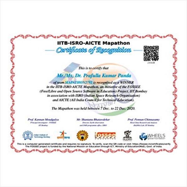
Mapathon winner 2020 and 2021
Mapathon is map making competition for a specific problem statement. This event was organised jointly by IIT Bombay, AICTE and ISRO, to produce maps using Indian remote sensing data. The primary objective was to understand the potential of Indian remote sensing data and make maps for Indian regions using free open-source mapping software (QGIS). The Team […]
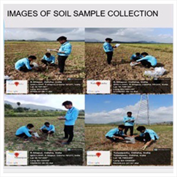
Ongoing summer internship program on Spatio Temporal Analysis of Soilfrom 16th May 2022 to 18th June 2022 @ CUTM, Odisha.
Digital soil mapping is the generation of geographically referenced soil databases and prediction of soil classes or properties from point data using a statistical algorithm.It represents a quantitative relationships between spatially explicit environmental data and measurements in the field and laboratory.Objective of the studyto identify spatial temporal variability of Soil and to develop digital Soil […]


Media


")

Our Main Teachers

Prafulla Kumar Panda working as an Assistant professor in department of civil engineering at Centurion University of Technology and Management. He obtained his B.Sc from Utkal university, Odisha ,M.Sc from Berhampur university Odisha, M.Tech from BharathiDasan University, Tamilnadu. He is previously worked at IIT Kanpur as Research Associate (2009-2011).He visited different countries such as UK, […]

Dr. Kamal Kumar Barik is presently working as Associate Professor, Dept. of Civil Engineering, CUTM, Bhubaneswar Campus. He did his Ph.D. at SRM University, Chennai in the field of Remote Sensing and GIS. He has been more than 8 years of teaching experience at Post Graduate level (M.Sc. and M.Tech.). Previously he was served as […]